CLIMATE
WHAT INFLUENCES THE CLIMATE OF THE ATLANTIC MARITIME ECOZONE?
The Atlantic Maritime ecozone has a climate that is heavily influenced by its proximity to the Atlantic Ocean. Due to the nearby presence of a large body of water, the ecozone experiences a maritime climate. The winters tend to be relatively mild, with the average temperature being -4°C during this season; while the summers are moderately warm, with the temperature averaging at 17°C during this period of time. Keeping these figures in mind, it can be seen that the range between these seasonal temperatures isn't extreme and is relatively small in comparison to ecozones that are located within the interior of Canada. For example, the Prairie ecozone experiences a temperature range of 33°C and therefore a continental climate, as opposed to the Atlantic Maritime, whose temperature range is 21°C. The primary reason of this difference between climate is the moderating effect of the Atlantic Ocean. Water tends to heat and cool at a slower rate than land does, which is why the areas near the ocean stay cooler during the summer and warmer during the winter. Since the ecozone is located at a coastal area, it also tends to receive high amounts of precipitation. The air masses that form over the Atlantic Ocean contain a lot of moisture, which falls as rain and/or snow once the winds carry it over onto the nearby land. As a result, the ecozone tends to get an average of 1000 to 1400 mm of precipitation annually. The Prairie ecozone only experiences 250 to 70 mm, which proves how the climate of the Atlantic Maritime ecozone differs from other ones. The Appalachian Mountain landforms that cover this region is also another factor that affects the climate. As the winds bring moist air from the ocean, the highlands act as a barrier and force the wind over and higher into the atmosphere. The air then condenses upon exposure to cooler temperatures and forms orographic clouds, which release the water droplets when the clouds becomes too heavy with them. The relief of the Appalachians influence the levels of precipitation within this ecozone. This area is also known as being the stormiest region in Canada due to the unpredictable behavior of the neighboring ocean. The growing season of the Atlantic Maritime generally lasts for 180-210 days, which shows that for a long period of the year, the temperature is reasonable enough for plant growth. It can thus be seen that this ecozone has a very complex and distinct climate pattern.
The Atlantic Maritime ecozone has a climate that is heavily influenced by its proximity to the Atlantic Ocean. Due to the nearby presence of a large body of water, the ecozone experiences a maritime climate. The winters tend to be relatively mild, with the average temperature being -4°C during this season; while the summers are moderately warm, with the temperature averaging at 17°C during this period of time. Keeping these figures in mind, it can be seen that the range between these seasonal temperatures isn't extreme and is relatively small in comparison to ecozones that are located within the interior of Canada. For example, the Prairie ecozone experiences a temperature range of 33°C and therefore a continental climate, as opposed to the Atlantic Maritime, whose temperature range is 21°C. The primary reason of this difference between climate is the moderating effect of the Atlantic Ocean. Water tends to heat and cool at a slower rate than land does, which is why the areas near the ocean stay cooler during the summer and warmer during the winter. Since the ecozone is located at a coastal area, it also tends to receive high amounts of precipitation. The air masses that form over the Atlantic Ocean contain a lot of moisture, which falls as rain and/or snow once the winds carry it over onto the nearby land. As a result, the ecozone tends to get an average of 1000 to 1400 mm of precipitation annually. The Prairie ecozone only experiences 250 to 70 mm, which proves how the climate of the Atlantic Maritime ecozone differs from other ones. The Appalachian Mountain landforms that cover this region is also another factor that affects the climate. As the winds bring moist air from the ocean, the highlands act as a barrier and force the wind over and higher into the atmosphere. The air then condenses upon exposure to cooler temperatures and forms orographic clouds, which release the water droplets when the clouds becomes too heavy with them. The relief of the Appalachians influence the levels of precipitation within this ecozone. This area is also known as being the stormiest region in Canada due to the unpredictable behavior of the neighboring ocean. The growing season of the Atlantic Maritime generally lasts for 180-210 days, which shows that for a long period of the year, the temperature is reasonable enough for plant growth. It can thus be seen that this ecozone has a very complex and distinct climate pattern.
This map shows the nearness of the Atlantic Ocean to the provinces that make up the ecozone.

An example of the precipitation levels and monthly temperatures experienced by a coastal city within this ecozone.
|

The Atlantic Ocean plays a critical role in providing a reduced temperature range and a source of moisture for the Atlantic Maritime ecozone.

High amounts of precipitation can be expected within the region.
|

A diagram that displays how the Appalachian highlands result in relief precipitation.
CASE STUDY: NEW-FOG-LAND
Perhaps one of the most breath-taking phenomenons to occur in Canada would be the veil of fog that seems to envelope the cities of Newfoundland (especially St. John's) for a countless number of days. Why is it that fishermen and sailors are told to be careful and take notice of the fog around the area? The answer lies within the influence of ocean currents around the maritime province. The thick fog forms when the warm Gulfstream current meets with the cold Labrador current along the coast of Newfoundland. When this happens, the air masses that were brought with these currents tend to mix upon contact. The moisture found within the warmer current cools down with exposure to a colder current and thus condenses. As the water droplets are suspended in the air, the clouding veil that we know as fog develops. The fog that can be found within this region is known for being quite dense and extremely widespread to the point where strong winds can't even disseminate it.
Perhaps one of the most breath-taking phenomenons to occur in Canada would be the veil of fog that seems to envelope the cities of Newfoundland (especially St. John's) for a countless number of days. Why is it that fishermen and sailors are told to be careful and take notice of the fog around the area? The answer lies within the influence of ocean currents around the maritime province. The thick fog forms when the warm Gulfstream current meets with the cold Labrador current along the coast of Newfoundland. When this happens, the air masses that were brought with these currents tend to mix upon contact. The moisture found within the warmer current cools down with exposure to a colder current and thus condenses. As the water droplets are suspended in the air, the clouding veil that we know as fog develops. The fog that can be found within this region is known for being quite dense and extremely widespread to the point where strong winds can't even disseminate it.

Fog covers the Cabot Tower in Newfoundland.
|

A village of Grand Bruit enveloped by fog during the early summer.
|
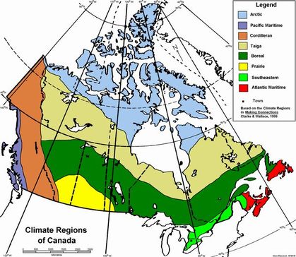
The Atlantic Maritime ecozone is part of the Atlantic Maritime and Southeastern climate regions of Canada.
